India has a unique and vast culture, and it is one of the oldest and greatest civilisations in the world. It is a Union of states, comprising 28 states and 8 Union territories in the country. As of 2026, India has approximately 800 districts, spread across 28 states and 8 union territories. This number is dynamic; state governments regularly create new districts for better governance and administrative efficiency. These districts are the administrative divisions, facilitating the governance of India, public administration, and the execution of government initiatives. So, let's explore the article in detail and check the complete State-Wise List.
What is a District in India?
A district (zila) is the primary administrative division within an Indian state or Union Territory (UT). Each district is governed by a District Magistrate (DM) or District Collector, who is typically an officer of the Indian Administrative Service (IAS). The district collector is responsible for:
-
Implementing central and state government policies
-
Maintaining law and order
-
Revenue collection and land records management
-
Coordinating welfare schemes and development activities
-
Disaster management and relief operations
Districts are further divided into tehsils (also called talukas or mandals), which are in turn divided into villages and urban local bodies.
How many Districts are in India?
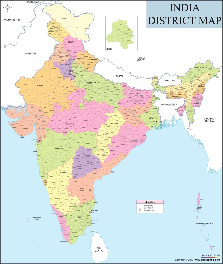
Source: Maps of India
There are approximately 800 districts in India.
| Category | Count |
| Total States | 28 |
| Total Union Territories | 8 |
| Total Districts (approx.) | 800 |
Official Source: The Government of India's Integrated Government Online Directory (IGOD) atigod.gov.in/districts — maintained by the National Informatics Centre (NIC), Ministry of Electronics & Information Technology — lists district-wise government websites. It was last updated April 17, 2026.
The National Portal of India atknowindia.india.gov.in/districts also provides state and UT-wise district information.
State-Wise Number of Districts in India
States
| State | Number of Districts |
| Uttar Pradesh | 75 |
| Madhya Pradesh | 55 |
| Rajasthan | 50 |
| Bihar | 38 |
| Tamil Nadu | 38 |
| Maharashtra | 36 |
| Assam | 35 |
| Gujarat | 33 |
| Telangana | 33 |
| Chhattisgarh | 33 |
| Karnataka | 31 |
| Odisha | 30 |
| Andhra Pradesh | 28 |
| Arunachal Pradesh | 27 |
| Jharkhand | 24 |
| West Bengal | 23 |
| Haryana | 23 |
| Punjab | 23 |
| Nagaland | 17 |
| Manipur | 16 |
| Kerala | 14 |
| Uttarakhand | 13 |
| Himachal Pradesh | 12 |
| Meghalaya | 12 |
| Mizoram | 11 |
| Tripura | 8 |
| Sikkim | 6 |
| Goa | 3 |
Union Territories
| Union Territory | Number of Districts |
| Jammu & Kashmir | 20 |
| Ladakh | 7 |
| Delhi (NCT) | 13 |
| Puducherry | 3 |
| Chandigarh | 1 |
| Dadra & Nagar Haveli and Daman & Diu | 3 |
| Andaman & Nicobar Islands | 3 |
| Lakshadweep | 1 |
Note: Numbers may vary slightly as new districts are announced by state governments through gazette notifications. Always refer to theofficial state government portals for the most current figures.
Largest and Smallest Districts in India
By Area
| Category | District | State/UT | Area |
| Largest | Kutch (Kachchh) | Gujarat | ~45,674 km² |
| Smallest | Mahé | Puducherry | ~8.69 km² |
Kutch district shares borders with Pakistan to the north and Rajasthan to the northeast. It alone accounts for over 23% of Gujarat's total geographical area.
By Population (Census 2011)
| Category | District | State | Population |
| Most Populous | Thane | Maharashtra | ~1.1 crore |
| Least Populous | Dibang Valley | Arunachal Pradesh | ~8,004 |
State with the Most and Least Districts in India
-
Most districts: Uttar Pradesh – 75 districts (also the most populous state with ~20 crore population)
-
Fewest districts: Goa – 2 districts (North Goa and South Goa)
Why Does the Number of Districts Keep Changing?
The number of districts in India is not static. State governments can create, merge, or rename districts through:
-
Executive Orders – by publishing a notification in the Official Gazette (the most common method)
-
State Legislature Bills – passed by the State Assembly
The Union Government (Centre) has no role in creating new districts — it is entirely a state subject. However, when a district or railway station is renamed, the Ministry of Home Affairs (MHA) is consulted, along with bodies such as:
-
Ministry of Earth Sciences
-
Intelligence Bureau
-
Department of Posts
-
Geographical Survey of India
-
Railway Ministry
Administrative Hierarchy in India
India's governance is structured in tiers from national to local:
Country: India
-
States & Union Territories: 28 States and 8 Union Territories
-
Divisions: 102 divisions (present across 18 states)
-
Districts: Approximately 800 districts
-
Sub-divisions / Tehsils / Talukas: Local administrative groupings within districts
-
Blocks / Community Development Blocks: Rural planning and development units
-
Villages / Gram Panchayats: The foundational local government level
How are districts administered in India?
A district is governed by several key officials:
-
District Magistrate (DM) / District Collector – IAS officer; head of civil administration
-
Superintendent of Police (SP) – IPS officer; head of law and order
-
Deputy Conservator of Forests (DCF) – IFS officer; in charge of forests and wildlife
-
District & Sessions Judge – Responsible for justice and judicial administration
-
Other district-level officers – Education, Health, Agriculture, Revenue, etc.
The District Headquarters (also called the "Collectorate") is the administrative centre of the district. Some major metropolitan districts — such as Mumbai City (Maharashtra), Kolkata (West Bengal), Hyderabad (Telangana), and Chennai (Tamil Nadu) — have no distinct district headquarters, despite having District Collectors.