Dhansiri River: Origin, Tributaries, Course, and Role in the 2026 Assam Floods
Dhansiri River is one of Northeast India's important rivers, flowing through Nagaland and Assam. Learn about its origin, tributaries, course, significance, and how it contributed to the Assam Floods of 2026
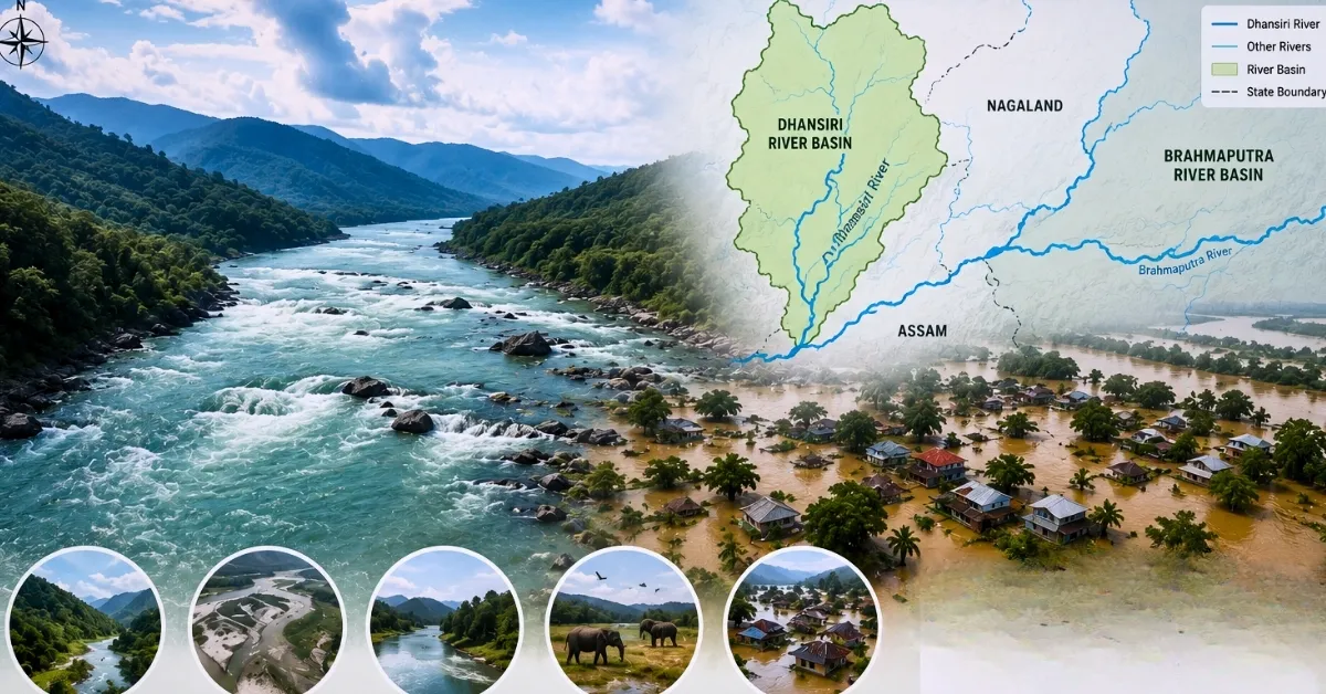
The Dhansiri River is a major tributary of Brahmaputra River. It plays an important role in the nagaland and Assam’s River system. It originates from the Laisang Peak region of Nagaland. Dhansisri the river flows through ecologically rich landscapes before joining the Brahmaputra in Assam.
Recently, the Dhansiri River came into the spotlight due to its rising water levels during the 2026 Assam floods, which caused widespread inundation in many districts.
Origin of Dhansiri River
The Dhansiri River is one of the main southern tributaries of the Brahmaputra River in Northeast India. It flows from the southwest corner of the Naga Hills, starting from the Laisang Peak in Nagaland, located at an altitude of around 800 meters above mean sea level (MSL).
In the history of the Ahoms, the river has been addressed as Khe-Nam-Ti-Ma (meaning "a river that flows from the place of water") and it runs for approximately 352 kilometers draining an area of nearly 12,200 square kilometers.
Course of the River: From Nagaland to Assam
From its mountainous origin at Laisang Peak, the Dhansiri follows a highly dynamic course:
-
First Segment: Initially, for 40 km, the river cuts northwestward and runs through the mountainous area of Nagaland.
-
State Division: It later turns northward, making a natural physical line of boundary between the Karbi Anglong district of Assam and that of Dimapur and Chümoukedima district of Nagaland.
-
Valley and Confluence: Once proceeding to the plain of Assam. The Dhansiri River flows mainly through Golaghat district as a primary river of this area.
-
It averages a width of 150m in its downstream stretch and ends at Dhansirimukh. A point at which it enters the south bank of the Brahmaputra River.

Major Tributaries of the Dhansiri River
The Dhansiri River is fed by an extensive network of sub-tributaries that drain the heavy monsoon rainfall from the surrounding hills.
| Bank | Major Tributaries |
| Left Bank Tributaries | Langlong River, Dhansiri (South), Diphu River (Diphupani), and various seasonal streams (janch) from Karbi Anglong. |
| Right Bank Tributaries | Dayang River (largest tributary), Khora River, Beopani River, and Kaliani River. |
What is the significance of the Dhansiri River?
The Dhansiri river basin is of great importance to the region in terms of multiple sectors:
- Environmental Parameters: The Dhansiri and Kopili Rivers through vigorous headward erosion over several millennia has completely cut off the Mikir Hills (Karbi Anglong) from the main Peninsular Indian plateau, thus forming a unique biogeographical area.
- Biodiversity: The river has adjacent vast wildernesses like the Dhansiri Reserved Forest and the Intanki National Park. Reports say that it comprises an interesting ichthyofauna of more than 34 species of fish (mostly belonging to the Cypriniformes and Siluriformes).
- Economic and agricultural importance: The lower plains of the basin area in Golaghat is a very productive agricultural area. The river supports large-scale paddy farming as well as provides water for prominent industrial organizations like the Numaligarh Refinery.
- Kaziranga National Park and Dhansiri River: The lower section of the Dhansiri River has a key responsibility for keeping the ecosystem of the Kaziranga National Park within. The natural overflow of the river during its wet seasons is what makes it possible for a vast system of flooded swamps, oxbow lakes, and bils to exist.
- These swamps happen to be the perfect inhabiting ground for freshwater fish and thereby help the wildlife of Kaziranga survive, including Great Indian One-horned Rhinoceros, Wild Water Buffaloes, and a variety of migratory birds.
Dhansiri River & How Did the Dhansiri River Contribute to the Assam Floods of 2026?
In the month of August of 2026, the Dhansiri River received a lot of attention in the headlines throughout the country due to an extremely serious hydrometeorological issue in Northeast India. Following a series of warnings from the Assam State Disaster Management Authority regarding the matter and public emergency advisory recommendations on the need for evacuation and avoiding the banks of the Dhansiri (South) River. The river hit the extreme and breached its dangerous levels.
In the monsoon flood disaster of July & August 2026, the Dhansiri River added significantly to the river runoff problem in Assam:
-
Cloudbursts and continuous rains in the high catches of Nagaland produced a massive amount of water. The stream, which was already filled with debris, flooded quickly out to the relief area.
-
The affected regions included Golaghat Sarupathar subdivision, where the floods flooded the important transportation routes between Barbali and Barbali Tup, inundating villages.
-
The effect on human beings involved loss of hundreds of hectares of rice land (grown by farmers using loans) as well as relocation of a large number of families in the first week of August alone, being provided with temporary relief facilities by the government like Amguri Bochpathar School camp.
Challenges Faced by the Dhansiri River Basin
The ecosystem of the Dhansiri River is under immense ecological stress:
-
Erosion and Rising of Stream Bed: Logging and some unscientific earth-excavating in the upper catchment area of Nagaland lead to a large amount of soil being washed off into the river.
-
This leads to serious siltation, thus leading to an increase in the riverbed, thereby decreasing its water-carrying capacity to the maximum and making it susceptible to bursting.
-
Heavy Riverbank Erosion: The river has a tendency to bend a lot in Assam plains. Therefore, the water, during monsoon season, rips away huge chunks of rich land along the banks, causing displacement of many agricultural communities.
-
Urban Encroachment and Pollution: As the river flows through important urban centres like Dimapur, it undergoes extreme ecological pollution. The unprocessed municipal waste, plastics, and trade waste are released into the river, thereby removing the oxygen content of water.
-
Climate Change: The normal rains have been replaced with unpredictable high-intensity and short-duration rainfall.

Manisha Waldia is a distinguished content strategist with 5 years of experience crafting premium educational content for UPSC and State PCS, with a focus on deep conceptual analysis across Polity, Geography, History, and Environment. She currently brings this expertise to Jagran Josh, where she covers major national and international events, current affairs, and static general knowledge. Over her career, Manisha's specialized insights have led her to curate high-impact materials and serve as a UPSC Mains answer-evaluator for India’s top institutes—including Drishti IAS, Shubhra Ranjan IAS, Study IQ, GS Score, and PWonlyIAS. She has also worked alongside leading NGOs like Oxfam India and Avani Kumaon.
Contact: manisha.waldia@jagrannewmedia.com


-1786186420903_t.webp)

![[लाइव] UPTET Result 2026: इंतजार खत्म! यूपी टेट रिजल्ट upessc.up.gov.in पर होगा घोषित, कैंडिडेट्स ऐसे कर सकेंगे चेक](https://img.jagranjosh.com/images/2026/August/782026/up-tet-result.jpg)