What is Equal Earth Map Projection? Know Why the UN Voted to Replace Mercator World Map
The United Nations General Assembly voted 164-1 to promote equal-area map projections like Equal Earth. Spearheaded by Togo, this shift aims to end centuries of Mercator distortions, correctly depicting the true scale of equatorial regions across South Asia, Africa, and South America.
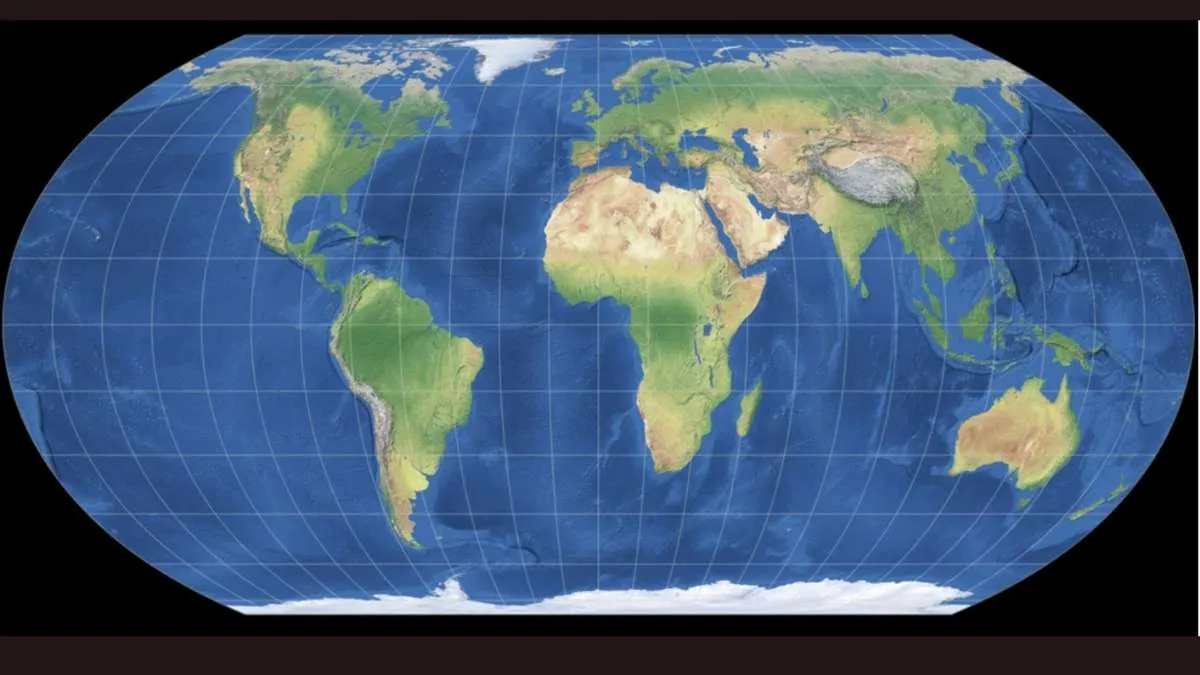
The UN General Assembly voted 164 to 1 to drop 500 year old Mercator world maps on September 4 2026. The UN assembly urged governments to switch to the Equal Earth map projection in classrooms and digital apps.
The assembly which was led by Togo and supported by the African Union aims to fix old mapping errors that make equatorial countries look small.
India voted for the resolution to support fair mapping for developing nations though the Ministry of External Affairs made sure to point out that any map used must still get India's national borders right.
What is the Equal Earth Map Projection?
The Equal Earth map is a flat world map drawn in 2018 by cartographers Bojan Šavrič, Tom Patterson, and Bernhard Jenny. They designed it specifically to show every country at its true relative size without twisting the shapes of the seven continents too much.
Why Mercator World Map Distorts Geography
Most world maps we see on classroom walls and phone screens use the Mercator projection. The current world map was created by Gerardus Mercator in 1569.
Mercator built his map for ship captains who needed to sail in straight lines using a compass. He had to stretch out the top and bottom of the map to make those compass lines work on a flat page,. As a result the farther a place is from the Equator the bigger it looks on maps.
Mercator vs Equal Earth Map Projection
Here’s a quick note on the different World maps looks like when we compare them on the following basis:
| Feature | Mercator Projection (1569) | Equal Earth Projection (2018) |
| Main Purpose | Ship navigation using a compass | Showing real sizes of countries fairly |
| Size Accuracy | Distorts land drastically near the poles | Keeps true 1:1 area proportions |
| Africa vs Greenland | Shows them about the same size | Shows Africa 14 times larger |
| Size of India | Looks much smaller than it really is | Shows full 3.28 million sq km area |
| Country Shapes | Keeps local shapes accurate | Slightly flattens high northern areas |
🗺️ Infographic explaining different map projections and the advantages and limits of three projections: the Mercator, the Gall-Peters and the Equal Earth projections.
— AFP News Agency (@AFP) September 7, 2026
This follows the United Nations General Assembly voting to adopt a new world map that makes the African… pic.twitter.com/NTabZ15JVy
What is the True Size of Africa and India on Different World Maps?
Mercator stretches land near the North and South Poles. So Western countries and polar regions look quite big whereas places near the Equator look shrunken on the current world map.
Real Size of Africa
On a Mercator map Greenland (2.16 million sq km) looks just as big as Africa. In reality Africa covers 30.37 million square kilometers which makies it 14 times larger than Greenland.
Real Size of India
India covers 3.28 million square kilometers of total land mass. But on Mercator maps it looks smaller than Alaska (1.71 million sq km) even though India is actually almost twice Alaska's size.
Equal Earth maps fix these scaling errors so every country takes up its actual space on the page.
Why India Supported the UN Equal Earth Map Projection
India supported the UN resolution alongside other nations in the Global South to ensure textbooks and online media stop underrepresenting the size of developing countries.
First Secretary Raghoo Puri told the UN Assembly that fair maps help people understand geography without old historical biases.
But External Affairs Ministry spokesperson Randhir Jaiswal added a clear caveat that supporting the Equal Earth map design does not mean India agrees with how third-party websites draw regional borders. New Delhi insisted that any map distributed must correctly show Indian territory especially Jammu, Kashmir, and Ladakh.
Our response to media queries regarding a UN General Assembly resolution on equal-area world map ⬇️
— Randhir Jaiswal (@MEAIndia) September 6, 2026
🔗 https://t.co/sAnpGhX3fA pic.twitter.com/Cfyn3jMcOG
Why the US Voted Against and 6 Nations Abstained
The United States was the only first world country that casted its vote against the resolution. US representative Yaryna Ferencevych stated that the UN was wasting time fighting over centuries-old map projections instead of focusing on current global crises. She also called the effort an unnecessary political debate.
Six countries: Ukraine, Georgia, Estonia, Lithuania, Moldova, and Serbia chose not to vote. Ukraine explained that the Equal Earth supports fair country sizes for Africa and Asia. But it is concerning that changing World map standards without strict border rules might let bad actors redraw occupied territories on digital maps.

Harshita Singh is an education and general knowledge journalist with over 5 years of experience in educational writing. Specializing in US affairs and GK, Harshita has a track record of breaking down intricate geopolitical and historical subjects into clear, digestible insights for learners. Her strong background in text analysis, coupled with a Bachelor of Arts (Hons) in English from the University of Delhi, helps her produce authoritative, thoroughly researched content that empowers readers to engage confidently with global current affairs. For inquiries or academic insights, you can reach out to her directly at harshita.singh@jagrannewmedia.com.




![[OUT] EMRS Tier 2 Result 2026 Live: Download PRT, TGT and PGT Result PDF at nests.tribal.gov.in](https://img.jagranjosh.com/images/2026/August/3182026/EMRS-Tier-2-Result-2026.jpg)