Key Points
- Meghalaya, the 'Land of Clouds,' derives its name from Sanskrit.
- Mawsynram, Meghalaya, is the wettest place on Earth with 11,871 mm rain.
- The 'Meghalayan Age' began 4,200 years ago after a global drought.
India is a land full of wonder. From the tall, snowy peaks in the North to the calm, blue waters in the South, the country is a lively blend of colours, cultures, and beautiful views. People travel from all over the world to see its natural beauty.
In fact, there are places in India that are so magical they get compared to heaven on earth. But did you know there is one specific spot called the 'Land of Clouds'?
In this article, we will explore this misty paradise and will discover where it is, why it earned its famous name, and what makes it so special.
ALSO READ| Which Place Is Known As The Budapest Of India?
Which Place Is Called The Land Of Clouds?

Source: Meghalaya.gov.in
Meghalaya is famously known as the ‘Land of Clouds’. The name itself comes from the Sanskrit words Megh (clouds) and Alaya (abode).
Located in Northeast India, this mountainous state is bordered by Assam to the north and Bangladesh to the south. It earned its title because it is home to the wettest places on Earth, Mawsynram and Cherrapunji.
These areas get a lot of rainfall because of the unique shape of the Khasi Hills. The hills trap winds that carry moisture from the Bay of Bengal.
This geographic setup causes the clouds to rise and condense. As a result, the landscape is always covered in a thick, airy mist.
Quick Facts: Meghalaya at a Glance
| Feature | Details |
| State Name | Meghalaya (Sanskrit for "Abode of Clouds") |
| Capital | Shillong (often called the "Scotland of the East") |
| Formation | 21 January 1972 |
| Major Tribes | Khasi, Garo, and Jaintia |
| Wettest Places | Mawsynram and Cherrapunji (Sohra) |
| Key Attractions | Living Root Bridges, Nohkalikai Falls, Mawlynnong (Cleanest Village) |
| Geographic Region | One of the "Seven Sister States" of Northeast India |
IN CASE YOU MISSED| Which City is known as the Gateway to the North-East in India?
7+ Lesser-Known Scientific Facts about Meghalaya
- Mawsynram receives an average annual rainfall of about 11,871 mm, making it the rainiest spot on the planet.
- The famous Living Root Bridges are made from Ficus elastica trees; they grow stronger over time, unlike man-made steel bridges that rust in the humidity.
- Geologists recently defined a new unit of Earth’s history called the "Meghalayan Age", which began 4,200 years ago after a massive global drought.
- The state houses Krem Liat Prah, the longest natural cave in South Asia, carved over millions of years by acidic rainwater reacting with limestone.
- Mawlynnong was voted the cleanest village in Asia; the community uses functional bamboo dustbins and bans all plastic.
- In the Jaintia Hills, scientists discovered "electric mushrooms" (Roridomyces phyllostachydis) that naturally glow in the dark.
- The extreme rain is caused by "orographic lift", where the funnel-shaped hills force warm air to rise rapidly, cooling it into instant rain.
- Because the plateau was once under the sea, you can find 50-million-year-old seashell fossils embedded in the mountain rocks.
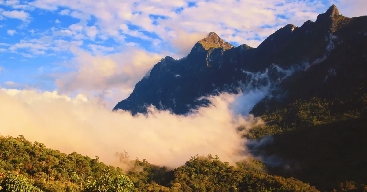
Why Is Meghalaya Called The Land Of Clouds?

Source: Wikimedia Commons
"Meghalaya" comes from the Sanskrit words "Megh", which means clouds, and "Alaya", which means home.
It literally translates to "The Abode of Clouds". There are specific scientific and geographical reasons why this state is always covered in mist.
i) The Funnel Effect
Meghalaya is shaped like a high plateau between the Brahmaputra Valley and the Bangladesh plains.
When the humid monsoon winds arrive from the Bay of Bengal, they hit the Garo, Khasi, and Jaintia Hills. The hills have a funnel shape that catches the clouds and pushes them up.
ii) Orographic Rainfall
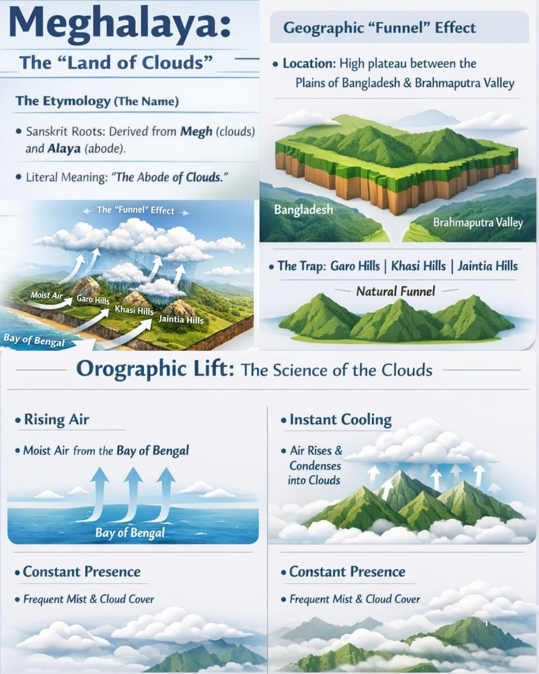
As the warm, moist air rises up the steep slopes, it goes through a process called orographic lift. As the air rises, it cools quickly.
Cool air cannot hold as much moisture as warm air, so the water vapour forms thick clouds and leads to heavy rain. This is why places like Mawsynram and Cherrapunji are the wettest places on Earth.
iii) High Altitude and Humidity
Most of the state sits at a high elevation, averaging about 1,500 metres. At this height, the humidity levels remain very high.
This creates a "cloud forest" environment where the ground and the sky often meet. This results in the well-known low-hanging mist that flows through the streets and forests.
iv) Constant Evaporation
The thick greenery and large forest cover in Meghalaya contribute to the cycle. The trees release moisture through transpiration.
This moisture quickly forms local mist and clouds in the cool mountain air, keeping the landscape constantly grey and white.
Why Does Meghalaya Get So Much Rain and Cloud Cover?
The reason why Meghalaya receives enormous amounts of rain is that:
- The geography of the state acts like a giant trap for moisture.
- The Bay of Bengal Connection: Warm, wet winds travel from the ocean toward the land.
- The Steep Wall: When these winds reach the Khasi Hills, they can only go up.
- Rapid Cooling: As the air rises, it cools quickly. This changes invisible water vapour into the thick, white clouds we see.
- Meghalaya not only receives rain from the ocean; it also generates its own mist. The millions of trees in the thick forests release moisture.
- Since the air is already so humid, this moisture turns into "ground clouds" that float through villages.
- Additionally, the Orographic lift is also the main cause. It is the scientific term for when mountains push air upward.
- In Meghalaya, this process is so effective that it results in the highest rainfall ever recorded by humans.
Conclusion: The Role of the "Cloud Forests"
While "Meghalaya" is a beautiful Sanskrit name, the title "Land of Clouds" reflects a real geographical feature. The state's location in the Northeast, along with its dramatic landscape, creates a constant display of nature's forces.
From the world-record rainfall in Mawsynram to the foggy Living Root Bridges of the Khasi Hills, the "Abode of Clouds" is one of the most important and visually striking areas in India.
WHAT'S NEXT| Which City is Known as the “Scotland of the East” in India?


-1768807676875.jpg)
Comments
All Comments (0)
Join the conversation