Zojila Tunnel Breakthrough 2026: Key Facts, Route, Cost, and Strategic Importance
Zorjila tunnel became thr world’s longest single-tube bi-directional road tunnel. Explore the historic Zojila Tunnel breakthrough achieved in 2026. Discover key facts, route maps, final costs and why this engineering marvel is India’s ultimate strategic asset for all-weather connectivity between Kashmir and Ladakh.
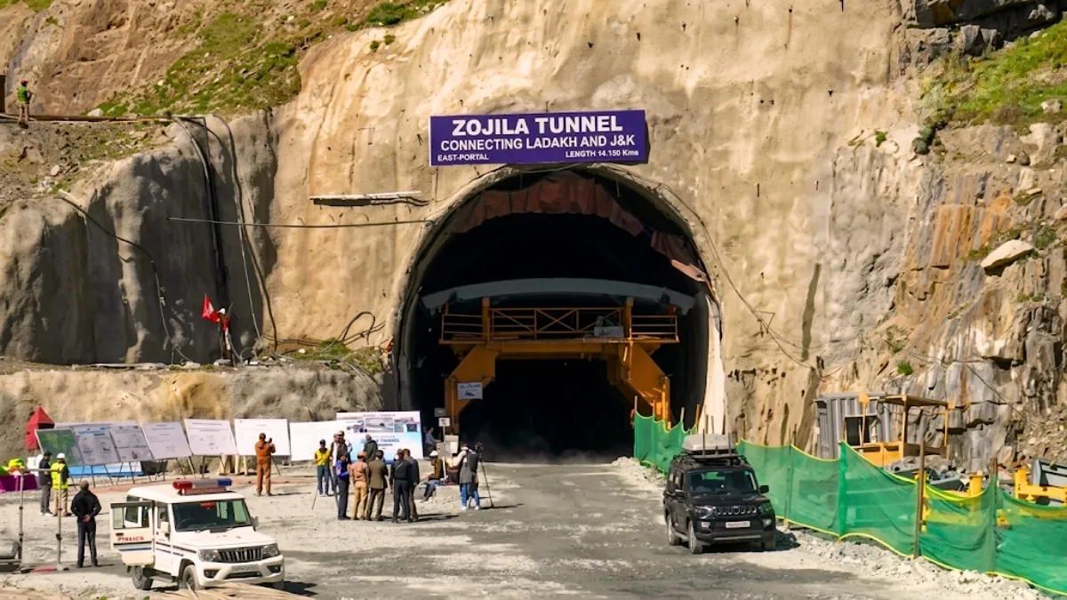
Union Minister for Road Transport and Highways Nitin Gadkari alongside Jammu & Kashmir Chief Minister Omar Abdullah and Lieutenant Governor Manoj Sinha pressed the remote button for a controlled blast at the East Portal near Minimarg in Ladakh.
Zorjila tunnel passed through its final explosion and pierced the last remaining 2.5-meter wall of rock. This breakthrough brings India’s decades-old dream of uninterrupted, all-weather connectivity between the Kashmir Valley and Ladakh.
The National Highways and Infrastructure Development Corporation Limited (NHIDCL) has announced that the tunnel will be officially thrown open for public and commercial traffic in February 2028.
Location and Geography of the Zojila Tunnel
The Zojila Pass is situated at the altitude of 11,578 feet on the Srinagar-Kargil-Leh National Highway (NH-1). The successful breakthrough on the Zorjila tunnel signals the end of season isolation during winter, heavy snowfall and deadly avalanches which choke the pass and entirely severing Ladakh from the rest of the country.
The Zojila Tunnel is a great example of geo-engineering carved directly into the rugged topography of the high altitude of Western Himalaya’s. Its physical and geographical location determines why this project is both a logistical necessity and an engineering extreme for India:
-
The tunnel centered around 34°16′44″N latitude and 75°28′19″E longitude.
-
The Tunnel is a horseshoe-shaped tunnel that operates at an average altitude of approximately 11,578 feet (3,529 meters) above sea level.
-
The tunnel runs directly underneath the historic Zoji La (Zojila Pass) in the local languages (Tibetan/Ladakh) "La" translates directly to "mountain pass," while Zoji is the historical interpretation of the "Mountain Pass of Blizzards."
-
The tunnel acts as a bridge between Kashmir Valley to its west and the Dras and Suru Valleys of Ladakh to its northeast.
Route and Map
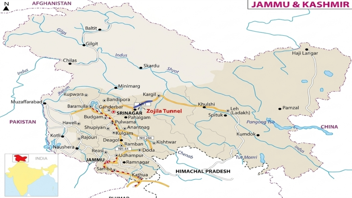
Source: PIB
The Zojila Tunnel project stretches seamlessly from the Ganderbal district of Central Kashmir to the Drass district in the Union Territory of Ladakh.
-
Starting Point: Baltal is the entrance point of a tunnel sitting roughly 15 km east of Sonamarg in the Ganderbal district of Jammu & Kashmir. This entrance rests at an elevation of about 3,000 meters, effectively bypassing the highest, most dangerous gradients of the surface highway.
-
Ending Point: Meenamarg or Minimarg located just ahead of Drass in the Kargil district of Ladakh. Drass is globally recognized as the second-coldest inhabited place on Earth which is the exiting point of the tunnel.
Travel Time Revolution of Zojila Pass
Generally the time taken to cross the Zojila Pass is 1.5 to 3.5 hours from anywhere which is heavily dictated by traffic jams and volatile weather. The new tunnel bypasses the treacherous curves by reducing the transit time to a mere 15 to 20 minutes.
The tunnel functions in tandem with the 6.5 km Z-Morh Tunnel located just before Sonamarg of Jammu & Kashmir establishes a continuous avalanche-free route from Srinagar all the way to Kargil and Leh.
Project Cost of Zojila Tunnel
The Zojila Tunnel is a fully centrally funded initiative executed under the Engineering, Procurement and Construction (EPC) mode. The Government of India provides the capital while the contractor handles execution risk before handing the operational asset over to the state.
| Parameter | Investment Details |
| Total Estimated Cost | ₹6,809.69 Crore (USD 815 Million) |
| Funding Structure | 100% Central Government Funded (MoRTH) |
| Socio-Economic Value | Employment generated for over 1,200 engineers, technicians and local youth |
Key Facts about the Zojila Tunnel
The construction of a mega-structure like Zojila Tunnel in a highly fragile, seismic-prone Himalayan region required unparalleled engineering grit. Here are the key facts about the Zojila Tunnel
-
Total Length: 13.153 km (Main tunnel). The entire corridor spans over 31 km when incorporating approach roads and connecting bridges.
-
Global Record: It is the world's longest single-tube, bi-directional road tunnel at an altitude exceeding 11,500 feet.
-
Dimensions: 9.5 meters wide and 7.57 meters high, featuring a horseshoe-shaped structure with a two-lane layout.
-
Executing Agency: Megha Engineering & Infrastructures Limited (MEIL).
-
Engineering Technique: Built utilizing the advanced New Austrian Tunnelling Method (NATM), aligned precisely with stringent European safety standards.
-
Safety Infrastructure: Equipped with automatic emergency lighting, high-tech ventilation shafts (sinking up to depths of 480 meters), emergency telephone booths, explicit message signaling systems, a dedicated 1.5-meter-wide maintenance walkway and continuous radio coverage.
-
Avalanche and Blizzard corridors to protect the tunnel from vertical rock walls, heavy accumulation of winter snow (often exceeding 30–40 feet), and hyper-frequent snow blizzards.
-
New Austrian Tunnelling Method (NATM): Engineers had to rely on the sequential excavation principles of the New Austrian Tunnelling Method (NATM) to safely hollow out this terrain without causing catastrophic collapses reinforcing the mountain with immediate shotcrete and extensive rock-bolting as they advanced.
-
It has emergency lay-bys located at intervals of 750 m staggered on both sides of the carriageway.
-
There are sidewalks on both sides of the carriageway and a telephone shall be installed at the emergency call niches.
-
Emergency call niches and hydrant niches are situated at intervals of 125 m.
-
Manual fire alarm push buttons and portable fire extinguishers shall be at the disposal of all drivers.
-
Fire Hydrants, Hydrant Niches and Fire Extinguishers.
-
Tunnel Lighting Systems: The Tunnel Lighting System represents the most significant part of the tunnel traffic safety and shall cover the following needs: entrance lighting, interior lighting and lay-bys lighting.
-
Video Surveillance system: CCTV-Cameras installed on the tunnel wall and the cameras in the area before and after the tunnel are installed on a pole.
-
The tunnel has a fire alarm system in buildings, automatic fire detection and suppression System in the tunnel and traffic control system with a central control room.

Strategic and Geopolitical Importance
The Zojila Tunnel holds immense geopolitical value for India beyond its status as an engineering masterpiece,
Logistics and National Defense
Ladakh shares sensitive, highly active borders with both Pakistan (Line of Control) and China (Line of Actual Control). Historically, the winter closure of the Zojila Pass heavily constrained military logistics, forcing the Indian Armed Forces to rely on expensive air-lifting operations to restock food, ammunition, and fuel supplies.
The tunnel ensures All time or 365 day strategic mobility by allowing rapid, round-the-clock troop deployments and heavy military convoy movements right up to the forward border posts, irrespective of external weather conditions.
Economic Significance
The local trade in fruits, handicrafts, and daily essentials will no longer face winter stalls by bridging the seasonal connectivity gap. Additionally, tourism will witness a massive transformation.
Tourism
Adventure enthusiasts, winter sports lovers and spiritual pilgrims visiting Buddhist monasteries or the holy Amarnath Cave will now enjoy secure, predictable year-round access to Sonamarg, Drass, Kargil and Leh. The project would enhance the safety of the travelers crossing Zozila Pass and would reduce the travel time from more than 3 hours to 15 minutes.
Humanitarian and Administrative Integration of the Region
The civilian population of Ladakh faced severe isolation during winters, struggling with limited healthcare access and soaring costs for essential commodities due to airfreight dependence. The Zojila Tunnel resolves this issue by seamlessly integrating the citizens of Jammu & Kashmir and Ladakh with the mainland's administrative and medical lifelines.
Difference between the Zojila Tunnel and Atal Tunnel
Both the Zojila Tunnel and the Atal Tunnel are considered as crown jewels of Indian engineering where both the tunnel located at high altitude but both serve completely different geographical corridors and different structural features includes
Feature | Zojila Tunnel | Atal Tunnel |
| Location (State/UT) | Jammu & Kashmir and Ladakh boundary | Himachal Pradesh |
| Mountain Range | Western Himalayan Range (Zojila Pass) | Pir Panjal Range (Rohtang Pass) |
| Route Connected | Srinagar to Kargil and Leh (NH-1) | Manali to Lahaul-Spiti Valley (Leh Highway) |
| Total Length | 13.153 km (Main Tunnel) | 9.02 km |
| Altitude / Elevation | 11,578 feet (3,529 meters) | 10,040 feet (3,060 meters) |
| Global Title | World’s longest single-tube, bi-directional road tunnel above 11,500 feet. | World’s longest single-tube highway tunnel above 10,000 feet. |
| Executing Agency | National Highways and Infrastructure Development Corporation Limited (NHIDCL) | Border Roads Organisation (BRO) |
| Primary Contractor | Megha Engineering & Infrastructures Limited (MEIL) | Strabag-Afcons JV |
| Total Project Cost | ₹6,809.69 Crore | ₹3,200 Crore |
| Current Status | Breakthrough achieved on June 9, 2026; Public opening set for February 2028. | Fully operational (Inaugurated on October 3, 2020). |
| Emergency Escape Layout | Features a built-in 1.5-meter-wide side walkway with advanced emergency exit portals. | Features a dedicated, separate escape tunnel built beneath the main traffic carriage. |
| Primary Strategic Focus | Immediate, direct tactical troop movement right up to the highly sensitive LoC and LAC lines. | All-weather logistical backup pipeline for the military and year-round connectivity to Himachal's tribal valleys. |
Zorjila Tunnel achieved its historic breakthrough of Zorjila Tunnel on June 9, 2026, marking the end of the most unpredictable phase of the project by carving through the heart of the Himalayas. As civil engineering transitions into advanced electromechanical outfitting over the next two years. The final rollout of the tunnel in February 2028 will forever redefine travel, safety and security in Northern India.

Manisha Waldia is a distinguished content strategist with 5 years of experience crafting premium educational content for UPSC and State PCS, with a focus on deep conceptual analysis across Polity, Geography, History, and Environment. She currently brings this expertise to Jagran Josh, where she covers major national and international events, current affairs, and static general knowledge. Over her career, Manisha's specialized insights have led her to curate high-impact materials and serve as a UPSC Mains answer-evaluator for India’s top institutes—including Drishti IAS, Shubhra Ranjan IAS, Study IQ, GS Score, and PWonlyIAS. She has also worked alongside leading NGOs like Oxfam India and Avani Kumaon.
Contact: manisha.waldia@jagrannewmedia.com


