Top 10 Indian States Prone To Cyclones and Earthquakes | Check Full List Here!
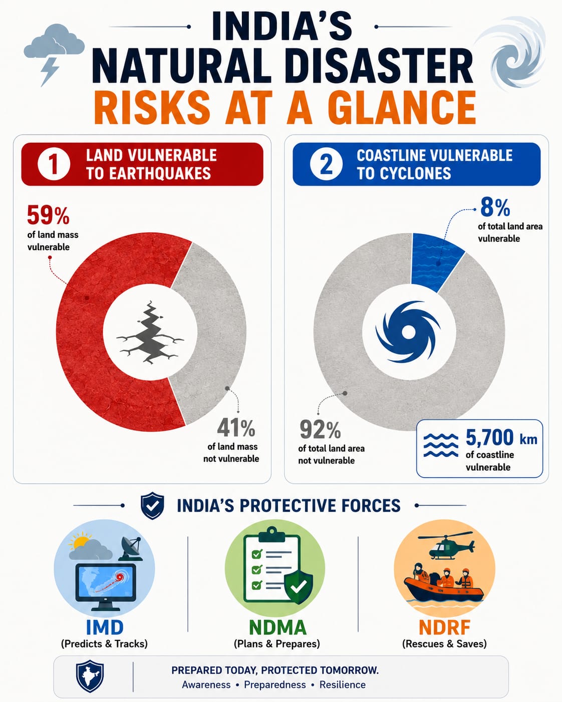
Almost 59% of India's land is prone to earthquakes, and about 8% is vulnerable to cyclones. Major coastal and Himalayan states face high risks. To protect citizens, government organisations monitor threats and handle emergency rescues nationwide.

India comprises 28 states and 8 union territories, boasting a wide array of landscapes and beauty. From tall rugged mountains to dry, arid deserts, you can find a variety of natural elements. India boasts a magnificent coastline spanning over 11,098.81 kilometres, stretching from the powerful Indian Ocean to the Bay of Bengal and the Arabian Sea, offering a kaleidoscope of vibrant marine life, busy ports and serene beaches.
But do you know this lively landscape turned into a dreadful nightmare for Indians on 26 January 2001, when a massive 7.7 magnitude earthquake hit the Kutch district of Gujarat near Chobari village in the Bhuj Taluka? This devastating earthquake took 13,800 to 20,000 lives and left 166,000 people injured. Nearly a million houses were destroyed due to this destructive earthquake, leaving people homeless in the peak winter season.
Destruction comes in the guise of earthquakes, floods, heavy rainfall, cyclones, droughts, famines, inflation, and more. In 1999, India was heavily struck by the most catastrophic cyclone of all time, Cyclone BOB 05. This cyclone made landfall on October 29, 1999, near Paradip, Odisha, as a Category 5-equivalent storm.
This cyclone brought relentless winds peaking at 260 km/h and a massive 20-foot (approx. 6-metre) tidal wave that surged miles inland, swallowing entire coastal villages. The storm engulfed millions of homes and destroyed 1.7 million hectares of cropland, wiping out the region's livestock and damaging infrastructure.
These two dreadful disasters were just the start; we can say the most horrific incidents happened in the past. But can you guess which Indian states are very prone to cyclones and earthquakes? Is UP, New Delhi, or Bihar on the list? Let's take a look at the Indian states which are directly affected by these cyclones and earthquakes.
List of 10 States That Are Prone to Earthquakes
India faces many earthquakes because its land is constantly moving and crashing underground. Let us look at the top 10 states of India.
| State | Region | Why is this state prone to earthquakes | Notable example |
| Gujarat | Western India | It has many underground fault lines, such as the Kutch Mainland Fault. When these lines slip, big earthquakes happen. | Bhuj Earthquake (2001, Magnitude: 7.7) – It killed over 13,800 people. |
| Jammu and Kashmir | Northern India | It lies right where the Indian tectonic plate pushes into the Eurasian plate, building immense pressure. | Kashmir Earthquake (2005, Magnitude: 7.6) - Caused massive destruction across the valley. |
| Himachal Pradesh | Northern India | The entire state lies within the young, active Himalayan mountain range, making the ground highly unstable. | Kangra Earthquake (1905, Magnitude: 7.8) – Wiped out thousands of old buildings. |
| Uttarakhand | Northern India | Located in the Main Central Thrust zone of the Himalayas, where rocks are under heavy stress. | Uttarkashi Earthquake (1991, Magnitude: 6.8) – Damaged thousands of homes in the hills. |
| Bihar | Eastern/Northern India | Its northern part lies very close to the active Himalayan boundary line and has soft soil that shakes easily. | Bihar-Nepal Earthquake (1934, Magnitude: 8.0) – One of the worst ever recorded. |
| Assam | North-Eastern India | Sits in the highest risk zone, Zone V. It is surrounded by active plates moving in different directions. | Assam-Tibet Earthquake (1950, Magnitude: 8.6) - Changed the course of rivers. |
| Mizoram | North-Eastern India | The land here is full of complex geological faults that frequently slip, causing tremors. | Champhai Earthquake (2020, Magnitude: 5.5) – Multiple tremors cracked many walls. |
| Nagaland | North-Eastern India | It is part of the Indo-Myanmar mobile belt, which is highly seismically active. | Nagaland Earthquake (2024, Magnitude: 5.5) - Felt strongly across the state lines. |
| Sikkim | North-Eastern India | Nestled in the high Himalayas, sandwiched between major fault systems that fracture the rocks. | Sikkim Earthquake (2011, Magnitude: 6.9) - Caused massive landslides in the rainy season. |
| Maharashtra | Western/Central India | Even though it is on a plateau, it has deep, hidden faults, such as the one near the Koyna dam. | Latur Earthquake (1993, Magnitude: 6.2) - Showed that even stable zones can shake. |
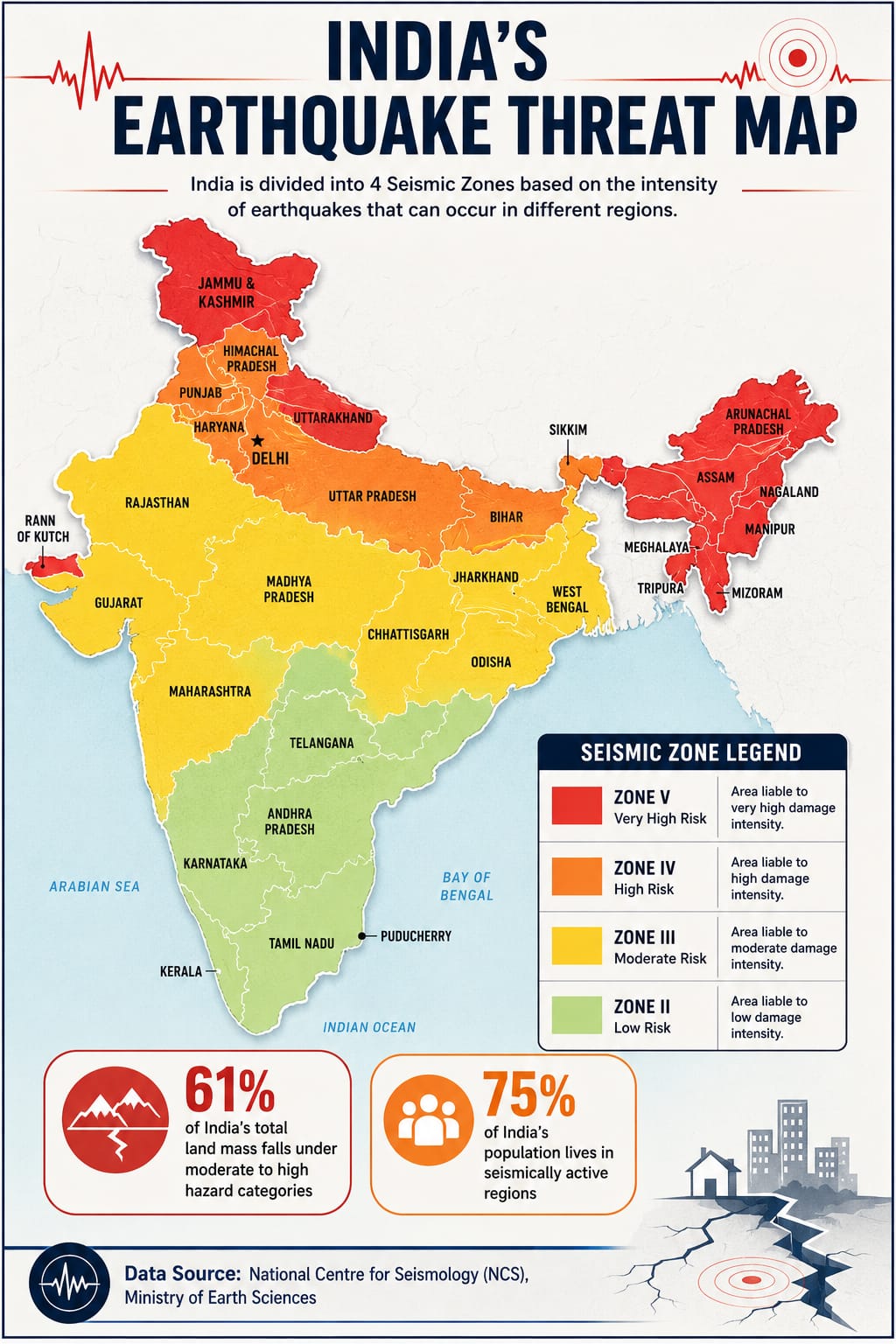
According to data published by the National Centre for Seismology under the Ministry of Earth Sciences, almost 59% of India's land area is vulnerable to earthquakes of varying intensities.
In fact, a recently updated seismic map by government agencies now suggests that about 61% of India's land falls under moderate to high hazard categories.
The country is divided into four main seismic zones: Zone II (low risk), Zone III (moderate risk), Zone IV (high risk), and Zone V (very high risk). Unfortunately, almost 75% of India's population lives in seismically active areas, meaning millions of people are always at risk.
Think of the Earth's crust like a giant jigsaw puzzle. The pieces, called tectonic plates, are always moving very slowly. The Indian plate is pushing northward into the Eurasian plate at a speed of about 4 to 5 centimetres every year.
Because they collide, energy gets trapped in the rocks. When the rocks can take it no more, they break, releasing energy that shakes the ground. That is what we call an earthquake.
List of 10 States That Are Prone to Cyclones
Cyclones are massive storms that form over oceans and bring heavy rain and fast winds to coastal areas.
| State | Region | Why is this state prone to cyclones | Notable example |
| Odisha | Eastern Coast | The Bay of Bengal is very warm, which feeds storms. The shape of Odisha's coast easily traps water. | Odisha Super Cyclone (1999, Speed: 260 km/h) – Nearly 10,000 people died. |
| Andhra Pradesh | Eastern Coast | It has a long coastline of 974 km that sits directly in the path of returning monsoon depressions. | Cyclone Hudhud (2014, Speed: 185 km/h) - Caused massive damage to Vizag city. |
| West Bengal | Eastern Coast | The shallow waters of the Sundarbans act like a funnel, causing storm surges to rise to extremely high levels. | Cyclone Amphan (2020, Speed: 185 km/h) - Flooded Kolkata and coastal villages. |
| Tamil Nadu | Southern/Eastern Coast | It gets hit during the Northeast monsoon season when the Bay of Bengal becomes very active. | Cyclone Gaja (2018, Speed: 140 km/h) - Uprooted millions of coconut trees. |
| Gujarat | Western Coast | Though the Arabian Sea has fewer storms, its long coast faces cyclones that curve towards land. | Cyclone Tauktae (2021, Speed: 160 km/h) – The Strongest storm to hit it in decades. |
| Maharashtra | Western Coast | Rising sea temperatures in the Arabian Sea are now creating more frequent storms near Mumbai. | Cyclone Nisarga (2020, Speed: 110 km/h) - Made rare landfall close to Alibaug. |
| Kerala | Western Coast | It gets heavy rains and rough seas from storms forming in both the Arabian Sea and the Indian Ocean. | Cyclone Ockhi (2017, Speed: 150 km/h) - Damaged coastal roads and hurt fishermen. |
| Goa | Western Coast | It is a small coastal state that experiences heavy rain and strong winds when storms pass to the north. | Cyclone Tauktae (2021) - Caused power cuts and destroyed property. |
| Karnataka | Western Coast | Its coastal districts, like Udupi, are hit by high waves and strong winds when cyclones brew nearby. | Cyclone Phyan (2009, Speed: 90 km/h) - Brought unexpected heavy downpours. |
| Puducherry (UT) | Eastern Coast | Encircled by Tamil Nadu, this coastal region is hit by almost every storm crossing the southern bay. | Cyclone Thane (2011, Speed: 140 km/h) - Caused severe damage to the infrastructure. |
India has a vast coastline stretching over 11,098.81 kilometres, out of which around 5,700 kilometres (76%) are highly prone to cyclones and tsunamis.
According to data from the National Disaster Management Authority (NDMA), about 8% of the country's total land area and one-third of its entire population are vulnerable to these disasters.
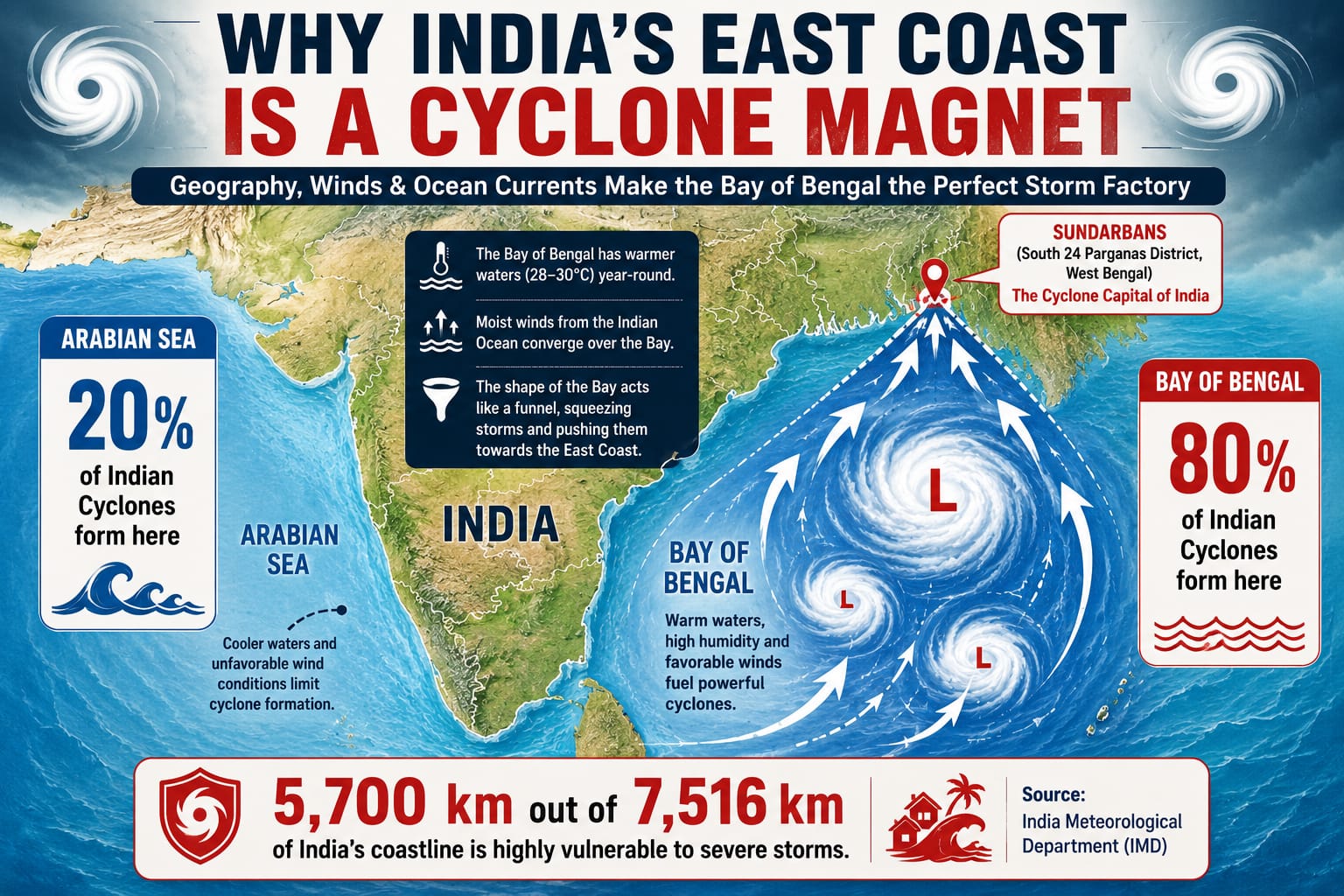
The Indian Meteorological Department (IMD) reports that out of the 96 coastal districts in India, 12 districts are classified as "very highly prone" to cyclones, while 41 districts are "highly prone".
Most cyclones hit the eastern coast because the Bay of Bengal is shaped like a triangle. When warm winds blow over water that is hotter than 26.5 degrees Celsius, it creates a low-pressure zone. Air rushes into this area and starts spinning due to the Earth's rotation.
This spinning monster collects water vapour, turning into a massive storm that crashes into our states, bringing high winds and flooding sea waves called storm surges.
How Much Area Of India Is Prone To Cyclones?
Out of India's total 11,098.81 kilometres of coastline, about 5,700 kilometres are highly vulnerable to cyclones. According to the National Disaster Management Authority (NDMA), this covers nearly 8% of the country's total land mass. Furthermore, around one-third of India's total population lives in coastal areas, meaning millions of people across 9 coastal states and 2 Union Territories face a constant risk from these massive ocean storms every year.
Which Indian Coastline Is Most Affected By Cyclones?
The eastern coastline of India, which faces the Bay of Bengal, is affected far more than the western coast. In fact, historically, nearly 80% of all cyclones that strike the Indian subcontinent form in the Bay of Bengal and crash into the eastern coast. The unique concave, triangular shape of this bay acts like a funnel, forcing the storm waters to pile up and strike the land with destructive force.
Which Indian State Is Most Prone To Cyclone?
Odisha is the most cyclone-prone state in India. Because of its geographic position on the East Coast and the shallow depth of the Bay of Bengal nearby, it sits directly in the path of the region's deadliest storms. Records from the India Meteorological Department (IMD) show that Odisha gets hit by nearly 20% of all cyclones affecting the country, making its coastal districts highly vulnerable to severe flooding and wind damage.
Do Cyclones Occur In The Indian Ocean?
Yes, cyclones occur frequently in the North Indian Ocean, which includes both the Bay of Bengal and the Arabian Sea. While the Bay of Bengal sees the majority of these storms due to its warmer waters, the Arabian Sea has also seen a rise in intense cyclones over recent years due to increasing ocean temperatures. The official cyclone season here peaks twice a year: from April to June and from October to December.
Which Is The Cyclone Capital Of India?
The Sundarbans in West Bengal, especially the South 24 Parganas district, is officially known as the "Cyclone Capital of India". The India Meteorological Department's Climate Hazards and Vulnerability Atlas shows that this area faces more severe cyclones and storms than anywhere else in the country.
What Is The Deadliest Cyclone In India?
The deadliest cyclone to strike mainland India in modern history was the 1999 Odisha Super Cyclone. Making landfall on October 29, 1999, with winds screaming at 260 km/h, it brought a massive 20-foot tidal wave that swept miles inland. The storm officially claimed 9,887 human lives, though unofficial numbers are much higher, and it completely destroyed over 1.7 million hectares of ready-to-harvest crops.
What Is The Safest Place To Be During A Cyclone?
The safest place to be is inside a specially engineered, concrete cyclone shelter built by the government on high ground. If you are at home, stay inside a sturdy, permanent brick-and-concrete building, away from windows and glass doors. Choose an interior room on the ground floor, like a hallway or bathroom. Never stay in a thatched hut, a house with a tin roof, or near open glass areas.
How Many Zones Of Earthquakes Are There In India?
India is divided into four main seismic zones based on how heavily the ground is expected to shake. These are Zone II (low damage risk), Zone III (moderate damage risk), Zone IV (high damage risk), and Zone V (very high damage risk). Originally, there was a Zone I, but government scientists merged it into Zone II because almost no part of India is completely free from the risk of tremors.
Which Zone In India Is Most Earthquake Prone?
Zone V is the most earthquake-prone zone in India, carrying a "very high damage risk". This zone covers about 11% of the country's total land area. It includes the entire northeastern region, parts of Jammu and Kashmir, Himachal Pradesh, Uttarakhand, the Rann of Kutch in Gujarat, and the Andaman and Nicobar Islands. These areas sit directly on active fault lines where tectonic plates crash together.

Kriti Barua is a skilled digital journalist and communications professional with 4+ years of experience, currently writing for the General Knowledge section at Jagran New Media. She has established herself as a subject matter expert in History, Geography, Trending National and International News, Sports, Science, and Defence, producing clear, reliable, and search-optimised content that connects with readers worldwide.
Kriti holds a BA degree from Delhi University and a one-year diploma in TV Production and Journalism, an academic background that adds research depth and strong storytelling instincts to her writing. Her experience spans brand writing, content marketing, and digital media, giving her a sharp understanding of what makes content both helpful to readers and visible in search.
At Jagran New Media, she applies this expertise to national and international news coverage, query-based articles, and in-depth pieces across her specialist subject areas. Her content is defined by easy language, factual accuracy, strong keyword strategy, and reader-friendly storytelling.


